LiDAR-SLAMはここまで来た : F4-SLAM改良版による超高精細カラー点群
視聴回数
当社がこれまで開発・運用してきた LiDAR-Visual-SLAM 技術「F4-SLAM」をベースに、高精細カラー点群生成を強化した最新技術デモです。
本動画では以下の2種類のデータセットを使用しています。
■ MARS-LVIG island03
カラー点群を用いた fly-through visualization
岩肌などの高周波形状まで高密度に再現しています。
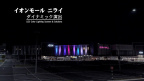
■ FAST-LIVO2 CBD_Building_01
FAST-LIVO2 との比較映像(上下2画面)
看板文字や細部形状の再現性、エッジの鮮明さ、拡大時の形状安定性をご確認ください。
本技術は、近年注目されている Gaussian Splatting 系レンダリングに匹敵する視覚品質を目指しながら、LiDAR-SLAMベースならではの幾何精度・形状安定性を両立しています。
特に以下のような特徴があります。
・高品質なカラー表現
LiDARとカメラを高精度に融合することで、鮮明で自然なカラー点群を生成します。
・正確な3次元形状
LiDAR計測に基づくため、実際のスケールや形状を正確に保持します。計測・デジタルツイン用途にも適した幾何精度を実現しています。
・視点変更や拡大にも強い安定性
視点移動やズームイン時でも、形状や色が崩れにくく、Gaussian Splatting系手法で見られるアーティファクトを抑制します。
・高速な点群生成
ニューラルネットワークの長時間学習を必要とせず、データ取得後に短時間で高品質なカラー点群を生成できます。
当社では、自律移動ロボット向けSLAM技術をベースに、3次元測定・デジタルツイン・空間認識用途への応用を進めていきます。
Title: LiDAR-SLAM Has Come This Far: Ultra-High-Definition Colored Point Clouds with the Enhanced F4-SLAM
Description:
This video demonstrates our latest LiDAR-SLAM technology, built upon our long-developed and field-proven F4-SLAM framework, with enhanced high-fidelity colored point cloud generation.
The following two datasets are used in this demonstration.
■ MARS-LVIG island03
Fly-through visualization using colored point clouds.
Fine high-frequency structures such as rocky surfaces are reconstructed with high density and detail.
■ FAST-LIVO2 CBD_Building_01
Side-by-side comparison with FAST-LIVO2 (top and bottom split screen).
Please observe the reconstruction quality of signboard text, fine structures, edge sharpness, and geometric stability during zoom-in visualization.
While aiming for visual quality comparable to recent Gaussian Splatting-based rendering approaches, our method also preserves the geometric accuracy and structural stability inherent to LiDAR-SLAM systems.
Key characteristics include:
* High-quality color reconstruction
By tightly fusing LiDAR and camera data, the system generates vivid and natural-looking colored point clouds.
* Accurate geometric reconstruction
Because the reconstruction is based on LiDAR measurements, true scale and geometric structure are preserved with survey-grade accuracy suitable for measurement and digital twin applications.
* Stable under viewpoint changes and zoom-in
Shapes and colors remain stable even during camera movement or close-up visualization, reducing artifacts commonly seen in Gaussian Splatting-based approaches.
* Fast point cloud generation without lengthy training
No time-consuming neural network pre-training is required, enabling high-quality colored point clouds to be generated shortly after data acquisition.
Our company continues to expand robotics-oriented SLAM technology into applications such as 3D measurement, digital twins, and spatial perception systems.
本動画では以下の2種類のデータセットを使用しています。
■ MARS-LVIG island03
カラー点群を用いた fly-through visualization
岩肌などの高周波形状まで高密度に再現しています。
■ FAST-LIVO2 CBD_Building_01
FAST-LIVO2 との比較映像(上下2画面)
看板文字や細部形状の再現性、エッジの鮮明さ、拡大時の形状安定性をご確認ください。
本技術は、近年注目されている Gaussian Splatting 系レンダリングに匹敵する視覚品質を目指しながら、LiDAR-SLAMベースならではの幾何精度・形状安定性を両立しています。
特に以下のような特徴があります。
・高品質なカラー表現
LiDARとカメラを高精度に融合することで、鮮明で自然なカラー点群を生成します。
・正確な3次元形状
LiDAR計測に基づくため、実際のスケールや形状を正確に保持します。計測・デジタルツイン用途にも適した幾何精度を実現しています。
・視点変更や拡大にも強い安定性
視点移動やズームイン時でも、形状や色が崩れにくく、Gaussian Splatting系手法で見られるアーティファクトを抑制します。
・高速な点群生成
ニューラルネットワークの長時間学習を必要とせず、データ取得後に短時間で高品質なカラー点群を生成できます。
当社では、自律移動ロボット向けSLAM技術をベースに、3次元測定・デジタルツイン・空間認識用途への応用を進めていきます。
Title: LiDAR-SLAM Has Come This Far: Ultra-High-Definition Colored Point Clouds with the Enhanced F4-SLAM
Description:
This video demonstrates our latest LiDAR-SLAM technology, built upon our long-developed and field-proven F4-SLAM framework, with enhanced high-fidelity colored point cloud generation.
The following two datasets are used in this demonstration.
■ MARS-LVIG island03
Fly-through visualization using colored point clouds.
Fine high-frequency structures such as rocky surfaces are reconstructed with high density and detail.
■ FAST-LIVO2 CBD_Building_01
Side-by-side comparison with FAST-LIVO2 (top and bottom split screen).
Please observe the reconstruction quality of signboard text, fine structures, edge sharpness, and geometric stability during zoom-in visualization.
While aiming for visual quality comparable to recent Gaussian Splatting-based rendering approaches, our method also preserves the geometric accuracy and structural stability inherent to LiDAR-SLAM systems.
Key characteristics include:
* High-quality color reconstruction
By tightly fusing LiDAR and camera data, the system generates vivid and natural-looking colored point clouds.
* Accurate geometric reconstruction
Because the reconstruction is based on LiDAR measurements, true scale and geometric structure are preserved with survey-grade accuracy suitable for measurement and digital twin applications.
* Stable under viewpoint changes and zoom-in
Shapes and colors remain stable even during camera movement or close-up visualization, reducing artifacts commonly seen in Gaussian Splatting-based approaches.
* Fast point cloud generation without lengthy training
No time-consuming neural network pre-training is required, enabling high-quality colored point clouds to be generated shortly after data acquisition.
Our company continues to expand robotics-oriented SLAM technology into applications such as 3D measurement, digital twins, and spatial perception systems.